Module:Location map is permanently protected from editing because it is a heavily used or highly visible module. Substantial changes should first be proposed and discussed here on this page. If the proposal is uncontroversial or has been discussed and is supported by consensus, editors may use {{edit template-protected}} to notify an administrator or template editor to make the requested edit.
This module is within the scope of WikiProject Maps, a collaborative effort to improve the coverage of Maps and Cartography on Wikipedia. If you would like to participate, please visit the project page, where you can join the discussion and see a list of open tasks.MapsWikipedia:WikiProject MapsTemplate:WikiProject MapsMaps
Location map is of interest to WikiProject Geographical coordinates, which encourages the use of geographical coordinates in Wikipedia. If you would like to participate, please visit the project page, where you can join the project and see a list of open tasks.Geographical coordinatesWikipedia:WikiProject Geographical coordinatesTemplate:WikiProject Geographical coordinatesGeographical coordinates
To help centralize discussions and keep related topics together, several talk pages redirect here.
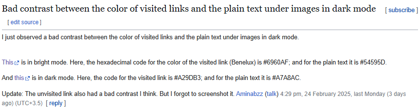
The map labels in dark mode have a black background and black text. The background should either be transparent on maps where the label text colour has sufficient contrast with the background or white so the black text has sufficient contrast. Here are three examples from Moulins, Allier, and Con Mine.
{{Location map~}}|background= is sometimes ignored when |position=bottom or |position=top
Example here in which the label background color is ignored for one element:
{{Location map~|France Paris and inner ring|lat=48.8737|long=2.2950|background = #ffcc7777|label=<div style="font-size:70%;">'''[[Arc de Triomphe]]'''<br />'''[[Place Charles de Gaulle]]'''</div>|position=top}}
In the above example, the color has partial alpha but that's irrelevant to the issue: I previewed |background=#ffcc77 and/or |position=bottom with same problem; changing |position=left or |position=right work OK. likewise changing other elements' |position= broke them.
According to the monthly parameter usage report, the |float= had only 1 use, which I removed. Furthermore, do we even need the CSS float:right when it's mostly in infoboxes, which are narrow? 142.113.140.146 (talk) 08:04, 1 August 2024 (UTC)[reply]
So I tested on mobile and saw the display. It is unclear why the controls are to the left of the image. I haven't heard of any UI pattern like this layout. On mobile, we should be spacing things out on the page with plenty of padding, not trying to cram everything on one row. 142.113.140.146 (talk) 19:56, 1 August 2024 (UTC)[reply]
Firstly, apologies for writing in English if this is not your first language (this is an automated message).
This template has been detected as one of 436 pages using styles that break the page when printed when the user is using dark mode. The fix is very straightforward - all your styles relating to dark mode must be scoped to. Since there is a high risk of this templates being copied to other wikis it is important this notice is acted on ASAP.
To fix this:
Update `@media (prefers-color-scheme: dark` to `@media screen and (prefers-color-scheme: dark`
Wrap any styles relating to `html.skin-theme-clientpref-night` in `@media screen`
If this message has not been acted on in 7 days, this will be fixed by an automated script. Thank you for your help fixing this important issue.
For any questions feel free to ask them at phab:T369874.
Hi, so is it possible with this template to like display for example the map of germany and cut the part that isn't of interest ?
For context I'm creating french pages for German Regionalligen and from 2012 til now it's fine since all 5 groups have location maps i can use, but for the period when it was divided into 3 groups there is no location map file for now and instead of creating new files (cuz i don't really know how to) i wondered if i can just used location map with the full germany map file, and then ask it to for example cut the south when showing regionalliga nord, then cut the north when showing regionalliga süd and then cut the east when showing regionalliga west.
If it's not possible then I'll go ask around on how to edit svg maps and create location maps ig TheÆtherPlayer (talk) 13:40, 7 October 2024 (UTC)[reply]
How do I set the Location map width to the reader's thumb size preference?
From the documentation, it appears that the |width= of the location map image is specified in pixels, but per MOS:IMGSIZE, Except with very good reason, a fixed width in pixels (e.g. 17px) should not be specified, because it ignores the user's base width setting. Thus upright=scaling factor is preferred when it is desired to present an image at other than the default width. How do I set the location map size to match the reader's thumb size preference, as recommended by MOS? – Jonesey95 (talk) 04:44, 12 March 2025 (UTC)[reply]
The context of MOS:IMGSIZE is clearly about stand-alone images, not ones in infoboxes. To have uniformly formatted infoboxes should be the standard. -- P 1 9 9✉18:03, 14 March 2025 (UTC)[reply]
I agree that a uniform image width should be the standard, which is why I am asking how to set a location map to match the reader's standard thumb size preference. MOS:IMGSIZE refers to the size of a "lead image". MOS:LEADIMAGE, on the same page, explains the lead image like this: It is common for an article's lead or infobox to carry a representative image. Module:InfoboxImage, which is commonly used to display lead images in infoboxes, has frameless and upright options, which allow lead images in infoboxes to comply with both MOS:IMGSIZE and with readers' preferences. So how do we follow this standard for location maps so that they match the infobox's lead image size? – Jonesey95 (talk) 19:26, 14 March 2025 (UTC)[reply]
Proposal: Add Custom Label Positioning in Module:Location map
I would like to propose an enhancement to Module:Location map that would allow for more precise label positioning. Currently, the module supports basic label positions (top, bottom, left, right), but does not include options for diagonal placements like northeast, northwest, southeast, or southwest.
Suggested Changes:
Expand the |position= argument to recognize and support:
northeast (ne)
northwest (nw)
southeast (se)
southwest (sw)
Benefits:
Greater Precision: Labels can be positioned more naturally relative to markers, reducing overlap and improving clarity.
Consistency: Many mapping tools and templates already support compass-based positioning, making this a logical extension.
Improved Readability: This would allow editors to optimize label placement in cases where the default positions (top, bottom, left, right) do not work well.
Possible Implementation:
Modify the |position= handling in Module:Location map to recognize the additional options and adjust label offsets accordingly.
Use a simple logic-based adjustment to move the label diagonally when a compass-based position is selected.
This enhancement would improve the flexibility and usability of location maps across Wikipedia. I welcome feedback and discussion on this proposal. Abhiramakella (talk) 23:42, 2 April 2025 (UTC)[reply]
The pushpin (pog) is just the default marker. Templates like {{Infobox airport}} use a different image file to show locations. There is a whole family of location maps, not just this module and template; I might support a name change if their name was something like "LM", but "Location map" is reasonably descriptive. – Jonesey95 (talk) 15:16, 1 May 2025 (UTC)[reply]
Description of suggested change:
the whole map section, including the caption, gets affected by the grayscaling effect on lines 66 and 79 in styles.css, which causes some weird coloring (see [1])


 Done Izno (talk) 23:48, 23 May 2025 (UTC)


