Patchogue station
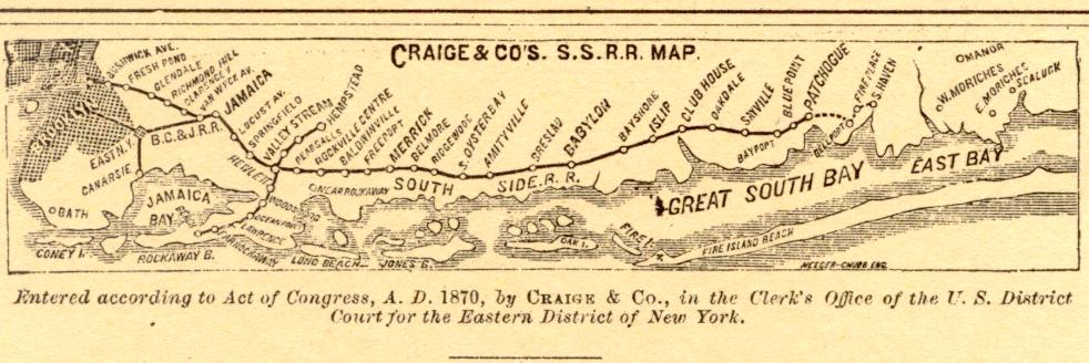
Patchogue (signed as Patchogue Fire Island Ferries) is a station of the Montauk Branch of the Long Island Rail Road in the Village of Patchogue, Suffolk County, New York. It is on Division Street between West Avenue (CR 19) and South Ocean Avenue. The station is the eastern terminus for some trains on the branch. Ferries to Fire Island board from a port near the station.[3] HistoryBetween 1869 and 1879 Patchogue station was the east end of the South Side Railroad of Long Island. It even had spurs and roundhouses between West and Railroad Avenues, as well as another spur between River Avenue and West Avenue for the textile plant that more recently has served as the former Patchogue Campus of Briarcliffe College. Prior to acquisition by the Long Island Rail Road there was a proposal by the SSRRLI to extend the main line southeast towards Bellport, then northeast to Brookhaven and Southaven. The station in Brookhaven was to be named "Fireplace" after Fireplace Neck.[4] The station was rebuilt in 1889 and again on July 30, 1963.[5][6] As part of the 1963 reconstruction, Railroad Avenue was terminated at Sephton Street, along the north side of the tracks, and the baggage and express house was torn down for additional parking. When the nearby Blue Point station was closed by the Long Island Rail Road in 1980, former Blue Point commuters opted to use Patchogue station.[5][6] A high-level platform was constructed at the station in the late 1990s, in order to serve the LIRR's then-new C3 bilevel railcars, which require high-level platforms.[5][6] The renovations also made the station compliant with the Americans with Disabilities Act of 1990.[5][6] Station layoutThe station has one high-level platform – long enough to accommodate six cars – and two tracks. The platform is located on the south side of the two tracks; the north track – not next to the platform – is a siding track.
PD Tower
 PD Tower was a former Long Island Rail Road control tower, located on South Ocean Avenue in the Village of Patchogue, in Suffolk County, New York, United States. HistoryIn 1912, the Long Island Rail Road added a control tower to the Patchogue station on South Ocean Avenue, for use by both the Montauk Branch and the former trolley line owned by the Suffolk Traction Company.[5][6][7] This control tower was designated by the LIRR as the "PD Tower" and was also used for hooping. In 1970, all switches and crossings once controlled by the tower were automated, but hooping continued. At this point, the tower's structure began to decline and deteriorate. Residents began referring to it as the "Leaning Tower of Patchogue," and it ultimately fell into a state of disrepair.[7] On August 23, 2006, PD Tower was ultimately torn down, having become structurally unsound.[7] Following the demolition of PD Tower, the land on which it stood was repurposed, being transformed into a flower garden.[7] Connections
See alsoReferences
External linksWikimedia Commons has media related to Patchogue (LIRR station).
|
||||||||||||||||||||||||||||||||||||||||||||||||||||||||||||||||||||||||||||||||||


Portal di Ensiklopedia Dunia


