Atlanta, Georgia
City of Atlanta alt = Atlanta montage. Clicking on an image in the picture causes the browser to load the appropriate article. From top to bottom, left to right: Downtown Atlanta skyline seen from Old Fourth Ward , the Center for Civil and Human Rights , World of Coca-Cola , CNN Center , Ebenezer Baptist Church at the Martin Luther King Jr. National Historical Park , the Georgia State Capitol , the Centers for Disease Control and Prevention , Midtown Atlanta skyline from Piedmont Park , Krog Street Tunnel , and Swan House at the Atlanta History Center
Flag
Seal
Nickname(s): Motto: Resurgens (Latin for rising again )
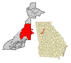
Location within Georgia
Show map of Georgia (U.S. state) Location within the United States
Show map of the United States Atlanta (North America)
Show map of North America Coordinates: 33°45′18″N 84°23′24″W / 33.75500°N 84.39000°W / 33.75500; -84.39000 Country അമേരിക്കൻ ഐക്യനാടുകൾ State Georgia Counties Fulton , DeKalb Terminus 1837 Marthasville 1843 City of Atlanta December 29, 1847 • Mayor Keisha Lance Bottoms (D ) • Body Atlanta City Council 136.76 ച മൈ (354.22 ച.കി.മീ. ) • ഭൂമി 135.73 ച മൈ (351.53 ച.കി.മീ. ) • ജലം 1.04 ച മൈ (2.68 ച.കി.മീ. ) • നഗരപ്രദേശം
1,963 ച മൈ (5,080 ച.കി.മീ. ) • Metro
8,376 ച മൈ (21,690 ച.കി.മീ. ) ഉയരം
738 to 1,050 അടി (225 to 320 മീ) 4,20,003 4,98,044 • റാങ്ക് U.S.: 37th • ജനസാന്ദ്രത 3,669.45/ച മൈ (1,416.78/ച.കി.മീ.) • നഗരപ്രദേശം
49,75,300 • നഗരജനസാന്ദ്രത 5,180/ച മൈ (1,999/ച.കി.മീ.) • മെട്രോപ്രദേശം
59,49,951[ 8] 9th ) •മെട്രോജനസാന്ദ്രത 1,350/ച മൈ (522/ച.കി.മീ.) • CSA
67,75,511[ 9] 11th ) • Demonym
Atlantan[ a] സമയമേഖല UTC−5 (EST ) • Summer (DST ) UTC−4 (EDT )ZIP Codes 30060, 30301–30322, 30324–30334, 30336–30350, 30340, 30353, 30363
Area codes 404 /678/470 /770 FIPS code 13-04000[ 11] GNIS feature ID0351615[ 12] Interstates Rapid Transit വെബ്സൈറ്റ് atlantaga.gov
അമേരിക്കൻ ഐക്യനാടുകളിലെ ജോർജിയ സംസ്ഥാനത്തിന്റെ തലസ്ഥാനമാണ് അറ്റ്ലാന്റാ നഗരം . വാണിജ്യപരമായും സാമ്പത്തികമായും വികാസം നേടിയ ഈ നഗരം ; രാജ്യത്തിന്റെ തെക്കു കിഴക്കൻ ഭാഗത്താണ് സ്ഥിതി ചെയ്യുന്നത്. രേഖാംശം 34o 42' വടക്ക് അക്ഷംശം 84o 26' പടിഞ്ഞാറ് അപ്പലേച്ചിയൻ പർവതങ്ങളുടെ തെക്കേ അറ്റത്ത് ബ്ലൂറിഡ്ജ് നിരകളുടെ അടിവാരത്തായി, സമുദ്രനിരപ്പിൽനിന്നും ഏകദേശം 330 മീറ്റർ. ഉയരത്തിലാണ് ഈ നഗരം സ്ഥിതിചെയ്യുന്നത്. തീരപ്രദേശങ്ങളെയും പടിഞ്ഞാറൻ ഉൾനാടുകളെയും ബന്ധിപ്പിക്കുന്ന അറ്റ്ലാന്റാ പ്രധാനപ്പെട്ട ഒരു ഗതാഗതകേന്ദ്രമാണ്; വ്യോമഗതാഗതവും റെയിൽ പാതകളും റോഡുകളും ഇവിടെ കേന്ദ്രീകരിച്ചിരിക്കുന്നു. വിമാനങ്ങൾ , മോട്ടോർ വാഹനങ്ങൾ എന്നിവയുടെ നിർമ്മാണം, ഇരുമ്പുരുക്കു വ്യവസായം, രാസവ്യവസായം, തുണിനെയ്ത്ത് എന്നിവ ഇവിടെ ധാരാളമായി നടക്കുന്നു. ജനസംഖ്യ: 420,003 (2010) ജനങ്ങളിൽ പകുതിയോളം കറുത്തവരാണ്. കറുത്തവരുടെ ഉന്നതവിദ്യാഭ്യാസത്തിനു പ്രാമുഖ്യം നൽകുന്ന അനവധി സ്ഥാപനങ്ങൾ ഇവിടെയുണ്ട്. അറ്റ്ലാന്റാ സർവകലാശാല, ജോർജിയാ ഇൻസ്റ്റിറ്റ്യൂട്ട് ഒഫ് ടെക്നോളജി എന്നിവയാണ് ഇവയിൽ പ്രധാനം
↑ "WSB-TV " . Archived from the original on October 28, 2014. Retrieved October 28, 2014 .↑ "The service, dubbed the Atlanta Tourist Loop as a play on the city's 'ATL' nickname, will start April 29 downtown." "Buses to link tourist favorites" Archived 2018-11-17 at the Wayback Machine The Atlanta Journal-Constitution ↑ "Because we're the only city easily identified by just one letter" . Creative Loafing . Retrieved October 7, 2012 .↑ "Atlanta Journal-Constitution , June 16, 2008" . Archived from the original on 2018-11-17. Retrieved October 28, 2014 .↑ "Our Quiz Column" . Sunny South . p. 5. Archived from the original on 2014-12-18. Retrieved 2020-05-04 .↑ "How Atlanta became the Hollywood of the South" . The Washington Times . Retrieved May 25, 2016 .↑ "2018 U.S. Gazetteer Files" . United States Census Bureau. Retrieved Feb 12, 2020 .↑ "Annual Estimates of the Resident Population: April 1, 2010 to July 1, 2018" . United States Census Bureau , Population Division. April 2019. Archived from the original on February 13, 2020. Retrieved May 30, 2019 .Archived 2020-02-13 at archive.today ↑ "Annual Estimates of the Resident Population: April 1, 2010 to July 1, 2018 – United States – Combined Statistical Area; and for Puerto Rico" . United States Census Bureau , Population Division. March 2018. Retrieved May 8, 2019 .↑ "Population and Housing Unit Estimates" . Retrieved June 4, 2019 .↑ "U.S. Census website" . United States Census Bureau . Retrieved January 31, 2008 .↑ "US Board on Geographic Names" . United States Geological Survey . October 25, 2007. Retrieved January 31, 2008 .


