| 名稱
|
照片
|
座標
|
海拔
(公尺)
|
省份
|
噴發次數
|
噴發事件與近況
|
| Ambalatungan Group |
|
17°18′40″N 121°06′13″E / 17.310982°N 121.103668°E / 17.310982; 121.103668 (Ambalatungan Group) |
7003232900000000000♠2,329米(7,641英尺) |
卡林阿省 |
0 |
1952年有不確定的噴發記錄[3]。火山噴發孔噴出硫氣與溫泉。
|
| Babuyan Claro |
|
9°31′23″N 121°56′24″E / 9.523°N 121.940°E / 9.523; 121.940 (Babuyan Claro) |
7003108000000000000♠1,080米(3,540英尺) |
卡加延省 |
3 |
1831年、1860年和1913年曾有過噴發記錄,在該火山南側出現溫泉。
|
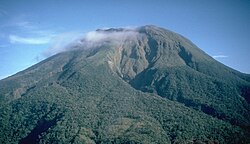
| 巴納豪火山 |
|
14°04′N 121°29′E / 14.07°N 121.48°E / 14.07; 121.48 (Banahaw) |
7003215800000000000♠2,158米(7,080英尺) |
奎松省 |
0 |
1730年、1743年、1843年和1909年間的土石流時有不確定的噴發記錄[4]。
|
| 比利蘭島 |
|
11°33′29″N 124°30′47″E / 11.558°N 124.513°E / 11.558; 124.513 (Biliran) |
7003130100000000000♠1,301米(4,268英尺) |
比利蘭省 |
1 |
1939年曾有蒸氣噴發,氣孔流出溫泉。
|
| 布盧桑火山 |
 |
12°46′12″N 124°03′00″E / 12.770°N 124.05°E / 12.770; 124.05 (Bulusan) |
7003156500000000000♠1,565米(5,135英尺) |
索索貢省 |
17 |
1886年至2011年間有多次噴發,長期監測中。
|
| 卡古亞火山 |
|
18°13′19″N 122°07′23″E / 18.222°N 122.123°E / 18.222; 122.123 (Cagua) |
7003113300000000000♠1,133米(3,717英尺) |
卡加延省 |
1 |
曾在1860年噴發,1907年有過硫氣外洩,熱流覆蓋區域從山的西北側至北北東側。
|
| Camiguin de Babuyanes |
|
18°49′48″N 121°51′36″E / 18.83°N 121.860°E / 18.83; 121.860 (Camiguin de Babuyanes) |
7002712000000000000♠712米(2,336英尺) |
卡加延省 |
1 |
僅在1857年有過噴發記錄,噴氣孔流出溫泉。
|
| 迪迪卡斯島 |
|
19°04′37″N 122°12′07″E / 19.077°N 122.202°E / 19.077; 122.202 (Didicas) |
7002244000000000000♠244米(801英尺) |
卡加延省 |
6 |
曾在1773年、1856年、1900年、1952年、1969年和1978年多次噴發。1952年以前是海底火山,其後成為火山島[5]。
|
| Hibok-Hibok |
 |
9°12′11″N 124°40′23″E / 9.203°N 124.673°E / 9.203; 124.673 (Hibok-Hibok) |
7003155200000000000♠1,552米(5,092英尺) |
卡米金省 |
5 |
Eruption in years 1827, 1862, 1871 and 1948–1952. Activity from 1897-1902 was only solfataric. Permanently monitored.
|
| Iraya |
|
20°28′08″N 122°00′36″E / 20.469°N 122.010°E / 20.469; 122.010 (Iraya) |
7003100900000000000♠1,009米(3,310英尺) |
巴丹群島省 |
1 |
Last eruption was in 1454. Seismic swarm in 1998.
|
| Iriga |
|
13°27′25″N 123°27′25″E / 13.457°N 123.457°E / 13.457; 123.457 (Iriga) |
7003119600000000000♠1,196米(3,924英尺) |
南甘馬仁省 |
0 |
The eruption in 1628 was discredited.[6]
|
| Jolo Group |
|
6°00′47″N 121°03′25″E / 6.013°N 121.057°E / 6.013; 121.057 (Jolo Group) |
7002811000000000000♠811米(2,661英尺) |
蘇祿省 |
0 |
Uncertain submarine eruption in 1897. Listed as Bud Dajo, a cinder cone on Jolo Island, in the PHIVOLCS list.
|
| 坎拉翁火山 |
 |
10°24′43″N 123°07′55″E / 10.412°N 123.132°E / 10.412; 123.132 (Kanla-on) |
7003243500000000000♠2,435米(7,989英尺) |
西內格羅省
東內格羅省 |
26 |
Eruptions were recorded from 1886 to 2006. Permanently monitored.
|
| Leonard Kniaseff |
|
7°22′55″N 126°02′49″E / 7.382°N 126.047°E / 7.382; 126.047 (Leonard Kniaseff) |
7003119000000000000♠1,190米(3,900英尺) |
北達沃省 |
0 |
Last eruption was dated as c.120 AD.[7] Strong thermal features.
|
| Makaturing |
|
7°38′49″N 124°19′12″E / 7.647°N 124.32°E / 7.647; 124.32 (Makaturing) |
7003194000000000000♠1,940米(6,360英尺) |
南拉瑙省 |
2 |
Eruption recorded in 1865 and 1882. The 1856 and 1858 eruptions was credited to Ragang[8][9]
|
| 馬圖滕火山 |
|
6°22′N 125°04′E / 6.37°N 125.07°E / 6.37; 125.07 (Matutum) |
7003228600000000000♠2,286米(7,500英尺) |
南哥打巴托省 |
0 |
Mountain was fumarolic on March 7, 1911, but if an eruption occurred was uncertain. Thermal springs in Almoan and Linan.[10][11]
|
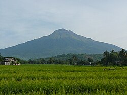
| 馬榮火山 |
 |
13°15′25″N 123°41′06″E / 13.257°N 123.685°E / 13.257; 123.685 (Mayon) |
7003246200000000000♠2,462米(8,077英尺) |
阿爾拜省 |
50 |
1616年至2009年間有多次噴發,長期監測中。
|
| 慕斯萬峰 |
|
7°52′37″N 125°04′05″E / 7.877°N 125.068°E / 7.877; 125.068 (Musuan) |
7002646000000000000♠646米(2,119英尺) |
布基農省 |
2 |
Eruptions in 1866 & 1867. Strong seismic swarm in 1976.
|
| 帕克火山 |
|
6°06′47″N 124°53′31″E / 6.113°N 124.892°E / 6.113; 124.892 (Mount Parker) |
7003182400000000000♠1,824米(5,984英尺) |
南哥打巴托省 |
1 |
A caldera-forming eruption occurred on January 4, 1641.
|
| 皮納土波火山 |
 |
15°08′N 120°21′E / 15.13°N 120.35°E / 15.13; 120.35 (Pinatubo) |
7003148600000000000♠1,486米(4,875英尺) |
三描禮士省
丹轆省
邦板牙省 |
3 |
Reawakened in 1991 producing the 2nd largest eruption in the 20th century. Followed by milder eruptions in 1992 and 1993.
|
| Ragang |
|
7°42′N 124°30′E / 7.70°N 124.50°E / 7.70; 124.50 (Ragang) |
7003281500000000000♠2,815米(9,236英尺) |
南拉瑙省
哥打巴托省 |
7 |
Eruption years are from 1765 to 1873. Eruptions were uncertain in 1915 and 1916.
|
| 內湖省火山地帶 |
 |
14°07′N 121°18′E / 14.12°N 121.30°E / 14.12; 121.30 (San Pablo Volcanic Field) |
7003109000000000000♠1,090米(3,580英尺) |
內湖省
八打雁省 |
0 |
Last activity was the formation of Sampaloc Lake around 1350 AD +/- 100 years determined by anthropology[12]
|
| 史密斯火山 |
 |
19°32′02″N 121°55′01″E / 19.534°N 121.917°E / 19.534; 121.917 (Smith) |
7002688000000000000♠688米(2,257英尺) |
卡加延省 |
6 |
Eruption years are from 1652 to 1924. Combined with Babuyan Claro on the GVP list.
|
| 塔阿爾火山 |
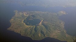 |
14°00′07″N 120°59′35″E / 14.002°N 120.993°E / 14.002; 120.993 (Taal) |
7002400000000000000♠400米(1,300英尺) |
八打雁省 |
33 |
Eruption years is from 1572 to 1977. Showing signs of unrest since 1991 and permanently monitored.
|
| 烏山頂泥火山 |
|
20°20′N 121°45′E / 20.33°N 121.75°E / 20.33; 121.75 (Unnamed volcano (Ibugos)) |
2998760000000000000♠−24米(−79英尺) |
巴丹群島省 |
3 |
曾在1773年、1850年和1854年有過海底噴發。
|


